· Travel · 9 min read
Highest Mountain in Morocco: Jebel Toubkal — Complete Guide to Climbing North Africa's Highest Peak
Discover the highest mountain in Morocco — Mount Toubkal at 4,167 m — with Imlil gateway, 2-day trek, difficulty, seasons and tips.
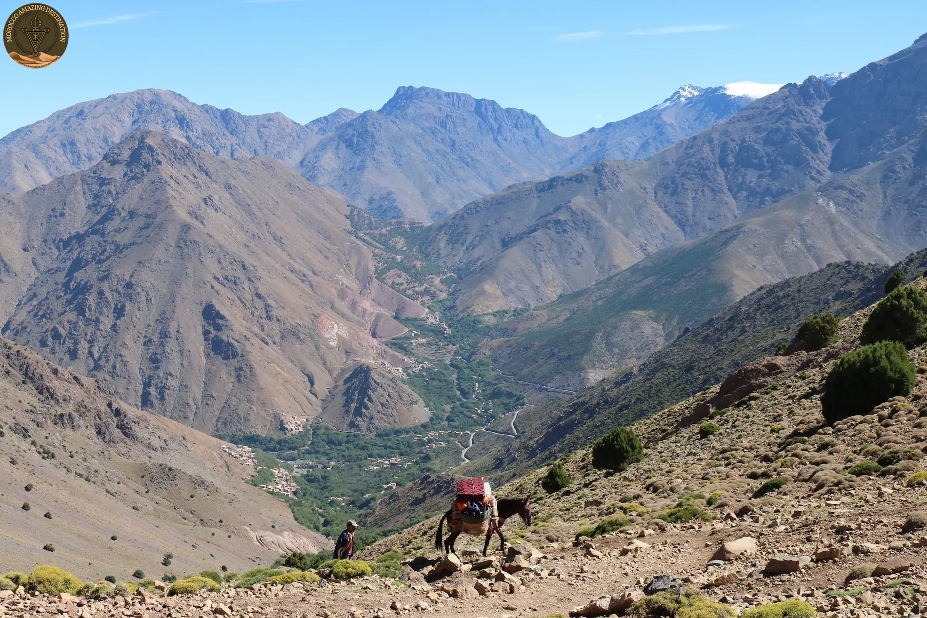
If you are planning an adventure from Marrakech into the mountains, one question comes up quickly: what is the highest mountain in morocco? The answer is Jebel Toubkal, a rugged pyramid of rock and scree rising to about 4,167 m in the heart of the High Atlas. Visible from Marrakech on clear days, it tops not only Morocco but all of North Africa, drawing trekkers who want a serious summit without technical climbing in the warm months. This guide explains where it sits, how high it really is, how to reach it from Imlil, and what to expect on the climb.
Where the Highest Peak Sits in the High Atlas
The High Atlas forms the backbone of Morocco, stretching from the Atlantic coast near Agadir eastward toward the Algerian border. It separates the green plains and cities of the north from the pre-Saharan valleys of the south, shaping weather, water, and Berber life for centuries. Within this chain lies Toubkal National Park, a protected area of about 380 square kilometres of deep valleys, juniper forests below and alpine rock above.
This is where you find the atlas mountains highest peak. Toubkal dominates the central High Atlas, standing head and shoulders above the surrounding 3,500–4,000 m summits. On a clear morning the massif can be seen as a snow-capped wall from Marrakech, about 63–65 km to the north — roughly 1.5 hours by road to the trailhead. The classic approach follows the Mizane Valley, with terraced fields, walnut groves, and Amazigh villages clinging to the slopes.
How High Is Toubkal? Understanding the Summit
Many travellers know the name but are unsure about the exact altitude. The peak is most commonly referred to in English as mount toubkal, and you will see both that and the Arabic-derived spelling on maps and signs.
Locally the mountain is widely known as jebel toubkal — Jebel simply means mountain — and in Tamazight as Adrar n Dern. All three names describe the same massif. The summit is marked by a distinctive pyramidal metal trig pillar where trekkers take their summit photos, with sweeping views north to the Marrakech plain and south toward the Anti-Atlas and the edge of the Sahara.
When people ask about toubkal height, the figure to remember is about 4,167 m (13,671 ft). You may still see 4,165 m quoted in older sources, but modern topographic mapping converges on about 4,167 m. Whichever figure you use, the key takeaway is that this is an ultra-prominent peak — rising about 3,755 m above the surrounding landscape — making it the highest point for more than 2,000 km in any direction, according to topographic data and encyclopaedic sources such as Britannica.
Imlil: The Gateway Village at the End of the Road
No climb begins without Imlil. Perched at about 1,740–1,800 m at the end of the tarmac road through Asni, this Berber village is about 63–65 km from Marrakech, roughly 1.5 hours by private transfer. It is the trailhead for almost every Toubkal ascent and a destination in its own right, with guesthouses, small shops, and mule teams that carry luggage up the valley.
The character of the place matters as much as the logistics. Terraced barley fields climb the hillsides, children lead mules along stone paths, and the Kasbah du Toubkal ecolodge sits just above the village offering panoramic views. Most trekkers spend a night here to acclimatize and meet their guide before starting early the next morning.
This is where the classic imlil toubkal trek begins. After Aroumd (also spelled Aremd) at about 1,840 m, the trail drops into the Mizane Valley and rises steadily past the shrine of Sidi Chamharouch at about 2,310 m — a whitewashed marabout beside a waterfall where pilgrims have stopped for generations. From there the path steepens toward the refuges at about 3,207 m, where you overnight before the summit day.
The Classic 2-Day Route to the Summit
Most fit hikers choose the standard two-day itinerary. A three-day variant via the Azzaden Valley and Tizi n Mzik adds acclimatization and scenery, but the two-day version remains the most popular.
Day 1 — Imlil to the Refuge (about 10–12 km, +1,460–1,540 m, 5–6 hours)
- Start early from Imlil (about 1,740 m) through Aroumd and the Mizane Valley.
- Pass Sidi Chamharouch (about 2,310 m), refill water, and continue on a well-worn mule track.
- Arrive at two stone refuges side-by-side at about 3,207 m: the historic Refuge du Toubkal (also called Neltner) and the private Refuge Les Mouflons. Both offer dormitory bunks, meals, and space to camp outside in season. Expect basic but welcoming facilities, hearty soups and tagines, and an early night.
Day 2 — Refuge to Summit and Back to Imlil (about 3–4 hours up, full day 9–11 hours)
- Pre-dawn start with headtorch, climbing the South Cwm over loose scree and blocky steps.
- Pass Tizi n Toubkal at about 3,950 m, then a final ridge to the summit at about 4,167 m.
- Summit time is brief — photos at the trig pillar, a snack, and layered views across the Atlas chain.
- Descend to the refuge for a short rest, then continue down the same Mizane path to Imlil, arriving in the afternoon. Total distance for the two days is roughly 22–28 km with about 2,300–2,470 m of cumulative ascent from Imlil.
The trail is non-technical in the warm months, meaning no ropes are needed, but it is consistently steep and loose underfoot. Trekking poles, ankle-support boots, and a steady pace make a real difference.
How Hard Is the Climb? Fitness and Altitude
Understanding toubkal climb difficulty helps you decide if the trek fits your experience. In late spring through autumn, Toubkal is a moderate to strenuous hike rather than a mountaineering route. You do not need to climb rock faces, yet you will gain a lot of height quickly, often on scree that slips underfoot, and you will feel the thin air above 3,000 m.
A useful benchmark is whether you can walk 15–20 km in a day with significant ascent while carrying a daypack. If that feels manageable, you are in the right range, provided you prepare for altitude. Symptoms of acute mountain sickness can appear above about 2,500–3,000 m, so a slow pace, good hydration, and an overnight at the refuge matter more than speed.
In winter the character changes completely. Snow and ice typically cover the upper mountain above about 2,800 m, turning the hike into an alpine winter climb that requires crampons, ice axe, and experience moving on snow. For that season, a licensed guide is essential, not optional. Even in summer, early starts help you avoid afternoon heat in the valleys and occasional thunderstorms, and wind chill near the summit can feel near freezing even when Marrakech is hot.
Best Seasons to Climb Toubkal
Timing shapes your experience more than any gear choice.
- Spring: Green valleys, wildflowers, and generally stable weather after mid-spring when much of the snow has cleared. Trails are clear, crowds are moderate, and light is excellent for photography.
- Summer: Warm valleys and cooler, windy conditions at altitude. Expect busy trails, especially on weekends, and plan a very early start. Summit temperatures may be 5–15°C with wind chill near freezing, so layers remain essential.
- Autumn: Often considered ideal — stable, clear skies, fewer trekkers than in peak summer, and crisp mountain air. Early autumn in particular offers excellent visibility.
- Winter: A snow-covered mountain for experienced hikers only. The refuges remain open with basic winter services, but you need full winter equipment and a qualified guide. The silence and snow scenery are memorable, but this is mountaineering, not hiking.
For most first-time visitors, late spring and early autumn offer the best balance of mild weather, dry trails, and manageable conditions.
Practical Tips: Guides, Gear and Logistics
A licensed mountain guide is effectively required inside the Toubkal massif — check with your operator and verify the guide’s badge. The national mountain guide school (CFAMM) certification is the standard, and official travel advice also recommends hiring a licensed guide and confirming credentials. Local operators note that guiding has been enforced more strictly inside the national park in recent seasons, so booking through a reputable provider avoids problems at checkpoints.
What an organized trek typically includes:
- Private or shared transfer Marrakech ↔ Imlil (about 63–65 km, roughly 1.5 hours each way)
- Licensed mountain guide and, where needed, muleteer with mules for luggage and food
- Meals on the mountain and overnight in a refuge dorm or gîte in Imlil
- Support with refuge booking and route decisions based on conditions
What to pack for a warm-season ascent:
- Sturdy, broken-in hiking boots with ankle support and gaiters for scree
- Layered clothing: moisture-wicking base, insulating mid-layer, windproof and waterproof shell, warm hat and sun hat
- Headtorch with fresh batteries for the pre-dawn summit push
- 2–3 litres of water capacity, snacks, sun protection (high SPF and sunglasses), and personal medication
- Trekking poles, small daypack, and a sleeping bag liner for the refuge
Winter adds: crampons compatible with your boots, ice axe, thermal base layers, insulated jacket, waterproof trousers, and heavier gloves. If you do not own winter hardware, reputable guides can arrange hire in Imlil, but confirm sizes and condition in advance.
Respect for the environment and culture matters along the way. Stay on the main path to limit erosion, carry out what you carry in, and ask before photographing people. The shrine at Sidi Chamharouch is a pilgrimage site — pause respectfully, keep voices low, and follow your guide’s advice.
Combine Your Climb with a Morocco Adventure
Toubkal sits close to Marrakech, so many travellers pair the trek with a broader itinerary that crosses the High Atlas. If you prefer a road-based introduction to the mountains before or after your hike, consider a desert loop that takes you over the Tizi n’Tichka pass.
A popular option is the 3-Day Trip from Marrakech to Merzouga, which climbs through the High Atlas to Ait Benhaddou and the Dades and Todra valleys before reaching the dunes of Merzouga — a great way to see the Atlas spine that Toubkal crowns. For a longer circuit, the 8-Day Morocco Tour: Marrakech, Sahara Desert & Essaouira Adventure links Marrakech, the Atlas, the desert, and the Atlantic coast in one flowing route.
Want more context on the range itself? Explore our sibling guides: Hiking the Atlas Mountains for trail ideas from gentle valley walks to multiday traverses, and Mountains of Morocco for an overview of the High Atlas, Middle Atlas, Anti-Atlas and Rif and how they fit together.
If you have your own timing, fitness level, or comfort preferences in mind, we can tailor the logistics for you.
We can customize a tour to match your needs — design your perfect itinerary
If you found this helpful, add us as your preferred source on Google.
Frequently Asked Questions
What is the highest mountain in Morocco and how high is it?
The highest mountain in Morocco is Jebel Toubkal (Mount Toubkal) at about 4,167 metres (13,671 ft). It is also the highest peak in the High Atlas, North Africa and the Arab world, inside Toubkal National Park south of Marrakech.
How long does the Toubkal climb take and how difficult is it?
The standard Imlil to Toubkal trek takes two days: day one hikes about 5–6 hours to the refuge at about 3,207 metres, day two makes a pre-dawn summit push to 4,167 metres and returns to Imlil (9–11 hours total). In summer it is non-technical but strenuous with scree and altitude; in winter it becomes an alpine climb requiring crampons, ice axe and a guide.
Do I need a guide to climb Mount Toubkal and what does a guided trek include?
A licensed mountain guide is effectively required inside the Toubkal massif — check with your operator and verify the guide's badge, as the national mountain guide school (CFAMM) certification is the standard. An organized trek typically bundles Marrakech pickup and return transfer to Imlil, a licensed guide, mule support for luggage, meals, and overnight dorm or gîte accommodation.
When is the best time to climb the highest mountain in Morocco?
The best seasons are spring and autumn when the weather is mild, skies are clear and the trail is dry. Winter brings snow and ice above about 2,800 metres and is only for experienced hikers with winter equipment, while summer is hot in the valleys but cooler at altitude and benefits from an early start.
Ready for an Adventure?
Have questions? Feel free to contact us using the form below. We're here to help!